Maryhill Trail 2:
South Maryhill via North Kelvinside and Queen’s Cross
“This portion of the Kelvin is possessed of many and various charms - wood, water and architectural grace being most effectively and pleasingly intermingled” - Hugh MacDonald, Rambles Round Glasgow, 1854
Maryhill - a part of Glasgow often overlooked on the standard tourist trails, something which these walking guides aim to help change!
Sandwiched between the peaceful sunken green corridor of the valley of the river Kelvin, and some stunning city views from the raised portions of the Forth & Clyde Canal, municipal Maryhill features a incredible amount of historic buildings, interesting architecture and important social and industrial heritage.
Come along and find out more...
This is a circular walk around 3 miles long. If you are coming from Maryhill Burgh Halls and the north, start at Ruchill Church Hall [1]. If you’re coming from the south or centre of town, it may be easier to start at Mackintosh’s Queen’s Cross Church [19]- a few minutes walk north up Maryhill Road from St George’s Cross Subway station.
1 Starting point: Ruchill Church Hall
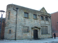 The low pale building is one of the most famous buildings in the area – a church hall, designed by Charles Rennie Mackintosh. The Hall dates from 1899
- pre-dating the church next to it. The tea-room here (open Mon-Fri, 11am-3pm) makes a great place to stop for a cuppa and a look around the interior, which is little changed from when it first opened, complete with original doors, folding partitions and decorative roof trusses. The red sandstone main church build- ing next door was built from 1903-05 as the Ruchill Street United Free Church, designed by the architect Neil C Duff.
The low pale building is one of the most famous buildings in the area – a church hall, designed by Charles Rennie Mackintosh. The Hall dates from 1899
- pre-dating the church next to it. The tea-room here (open Mon-Fri, 11am-3pm) makes a great place to stop for a cuppa and a look around the interior, which is little changed from when it first opened, complete with original doors, folding partitions and decorative roof trusses. The red sandstone main church build- ing next door was built from 1903-05 as the Ruchill Street United Free Church, designed by the architect Neil C Duff.
Cross Maryhill Road at the pedestrian crossing outside the Viking Bar, and head south down Shakespeare Street.
A number of the roads around this area have a Shakespearean theme - keep an eye out for Stratford Street and Hathaway Street... how many others can you spot?
2 Shakespeare Street School
 Shakespeare Street School on the left was built by the School Board of Glasgow in 1915 to the designs of McWhannel, Rogerson & Reid. It is currently empty and awaiting a new use. Opposite it, right, the curving modern tenement was a compe- tition-winning design by McGurn, Logan, Duncan & Opfer to create a ‘Twenty-First Century Tenement’ [3] at Craigen Court for Maryhill Housing Association.
4 Shakespeare Street Youth Club
The low metal-clad shed on the left is the surprisingly old but extremely active Shakespeare Street Youth Club. Origi- nally the Huw MacCowan Memorial Hall, it was founded after Huw was killed at Gallipoli in World War One.
5 Walcheren Barracks
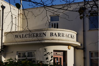 At the foot of Shakespeare Street on the left are Walcheren Barracks, portions of which date to 1938, and were originally built as a drill hall for the Glasgow Highlanders’ Territorials.
At the bottom of the road, turn left into Garrioch Road, then immediately take the first left into Hotspur Street.
Both Shakespeare Street and Garrioch Road were old estate roads. As the tenements developed, the area became known as North Kelvinside, to try to distinguish itself from the rest of ‘old’ Maryhill.
6 Kelbourne School
The current Kelbourne School was purpose built (in what was then called Percy Street) as an ‘open air’ school and opened in September 1914. Before that, the school had met in Maryhill Burgh Halls since 1907 - originally providing classes for ‘men- tally and physically defective children’. The School soon outgrew its makeshift premises at the Hall. A report from an Inspection in 1911, while mentioning the great work being performed by the teachers, said on the other hand that: “it is impossible to speak favourably of the premises, which are extremely unsuitable. A public hall used frequently in the evenings for public entertainments, lacking proper cloakrooms and playgrounds, devoid of suitable storage of apparatus, bare in appearance, and generally comfortless, should not be used for this purpose longer than is absolutely necessary...”
This scathing report led directly to the establishment of the purpose built school premises, which are still in use today.
Take the first right past the school, into Northumberland Street, just before Stow College.
Now Stow College West Campus, this was originally Garrioch School [7], built for the School Board of Maryhill in 1905, with a dramatic central columned window. To the south, the open land of North Kelvin Meadow [8] had been used as sports grounds for the school, and was originally the site of a grandstand for the short-lived Kelvinside Racecourse. Aerial photos taken during WW2 show a barrage balloon being moored here.
Turn left into Kelbourne Street.
9 Sorn Dairy
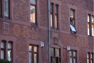 Up Sanda Street to the left was the Sorn Dairy - now converted to flats - but with the Dairy lettering still just visible on
the front and rear facades. This was a distribution centre for a collective of dairy farms near Sorn in Ayrshire.
Up Sanda Street to the left was the Sorn Dairy - now converted to flats - but with the Dairy lettering still just visible on
the front and rear facades. This was a distribution centre for a collective of dairy farms near Sorn in Ayrshire.
Further along Kelbourne Street on the right is the former North West Fire Station [10], built in red brick by Thomas Somers and manned from 1941 - replacing the earlier fire station in Gairbraid Avenue next to Maryhill Burgh Halls. In 1942, King George VI and Queen Elizabeth visited to see the station in action. The fire engine entrance was where the large green modern windows are, and a large internal central courtyard - including a tall drying tower for wet hoses! - was surrounded by housing for the firemen, now all converted to flats, and entered via Mingarry Street.
The gap site at the corner of Queen Margaret Drive and Kelbourne Street was the site of North Kelvinside Parish Church [11] which was demolished in recent years due to subsidence – look out for the fragments remaining next to the halls next door.
Continue and turn right onto Queen Margaret Drive; cross the road at the pedestrian crossing to the right. Carry on down Queen Margaret Drive, and head left up Wilton Street. Be careful to take the correct street here - it’s the second street on the left after the crossing, and the second-last before the bridge!
At the first junction, take a right into Kelvinside Terrace West, and a short distance along, look for the cast iron lamppost at the top of...
12 Alexander ‘Greek’ Thomson’s Sixty Steps
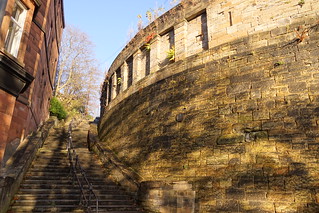 The Kelvinside Terrace retaining wall and steps were designed in the 1870s, and were originally linked to the now demolished Queen Margaret Bridge below. They also featured in the Gillian Anderson film House of Mirth, one of a number of locations in Glasgow standing in for New York. The lamppost at the top is original and thus a rare surviving relic of the Burgh of Maryhill. www.sixtysteps.org.uk
For a step-free route, head back to Wilton Street, and follow it back down to the right, rejoining the walk at point A. Otherwise, head down the Sixty Steps, and carefully cross the road at the bottom.
13 Remains of old bridge
Just ahead to the left is the start of the old bridge from 1870 - known as Walker’s Bridge. Look across the river from here to spot the far end of the bridge, and below the remains of some of the supporting stonework can be seen in the river.
Head to the right along the road, and look for the pedestrian gate in the fence on the left just before you rejoin Queen Margaret Drive. Head down these steps to the Kelvin Walkway. 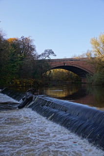 Keep an eye out - a heron often sits on the far bank here fishing. For more about the Kelvin Walkway, visit www.fork.org.uk.
Follow the Walkway downstream to the left, and notice the mill lade running alongside on the right.
Keep an eye out - a heron often sits on the far bank here fishing. For more about the Kelvin Walkway, visit www.fork.org.uk.
Follow the Walkway downstream to the left, and notice the mill lade running alongside on the right.
14 North Woodside Flint Mill
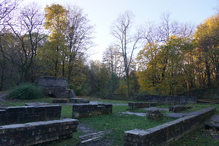 Water from the lade once powered the Woodside Flint Mill. The flint produced here was used in pottery making; but before this the mill had a long and varied life including grinding barley, corn, and possibly even paper bags for sugar. The site remained in use until the 1960s. The base of the kiln, its chimney cut down and now topped off with concrete, can be seen in the background. The concrete grinding wheels are a later addition.
Where the path splits, bear left on the wider path, and climb up the concrete steps leading up to Belmont Street, bringing you out opposite...
15 Kelvin Stevenson
Memorial Church
 Built by JJ Stevenson and H Redfern in 1902, Kelvin Stephenson Memorial Church is cunningly designed with its main entrance at street level, and the church halls tucked underneath. Inside, some of the stained glass is by Gordon Webster, whose father Alf once worked with Stephen Adam, the artist of the Maryhill windows. Look out for the carved animals on each side of the tower, the open steeple of which was based on that of King’s College, Aberdeen.
Turn left to follow Belmont Street uphill, where it bends to the right to rejoin Wilton Street at point A. An Optional Detour to St Charles Church can be taken from here - see boxout B below.
[B Optional detour: St Charles’
North Kelvinside Church
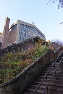 A brief side-step to the left off Wilton Street, up Melrose Gardens, and climbing the steep steps at the end brings you out next to the stunning St Charles’ RC Church, designed by Jack Coia and Andy MacMillan in 1959. The freestanding concrete bell tower can be seen from miles around, and the interior features a unique series of terracotta figures by sculptor Benno Schotz depicting the stations of the cross - one of which even features the architect!]
Continue down Wilton Street, through Wilton Street Gardens.
At the end of the Gardens, bear left into Wilton Drive.
16 William Primrose plaque
About halfway along Wilton Drive, look right at no. 18 to first floor level to spot a rather unusual plaque featuring a hand playing a Viola. This commemorates the birthplace, in 1904, of William Primrose - regarded as one of the greatest viola players of all time - and the only violist in history to have a star on the Hollywood Walk of Fame! He died in 1982, after a long career playing in America and all over the world.
Continue ahead into Dunard Street.
18 Dunard Street School
Dunard Street School on the left was designed by Steele & Balfour.
At the end of Dunard Street at Maryhill Road is the old Burgh Boundary. Opposite is one of the oldest pubs in the area, run by Walter Munn in the 1870s. We now briefly leave old Maryhill to take
in some of Queen’s Cross and Firhill on our way to join the canal.
Turn right onto Maryhill Road, and head down towards...
Queen’s Cross at the junction of Garscube Road and Maryhill Road was once marked by an impressive V-shaped tenement [18] designed by Alexander Greek Thomson that dates from 1875. It incorporated the Queen’s Cross Vaults pub and a billiard hall above at the narrow junction, facing a set of underground toilets and a police box! These were all sadly demolished in the 1980s as part of the redevelopments of the area.
NB: St George’s Cross Subway is a few minutes walk south down Maryhill Road (to the right) from here. Cross the road at the pedestrian crossing.
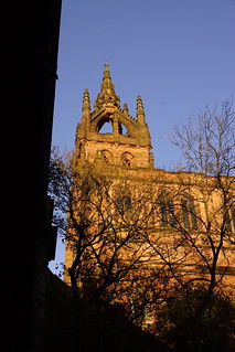
19 Mackintosh Church
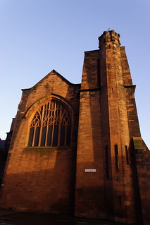 Thankfully the Mackintosh Church across the road still survives. Mackintosh’s only completed church design, it was built for the Free Church and opened in 1899. Although a prominent site, it presented difficulties as it was squeezed between the road and the enormous iron works that once sat directly behind it. The home of the Charles Rennie Mackintosh Society since 1977, the church has been restored to its former glory. Magnificent stained glass and exceptional relief carving on wood and stonework are highlights of the interior where light and space are used to dramatic effect. The Mackintosh Church at Queen’s Cross also has an excellent library and the shop stocks an extensive range of Mackintosh books and gifts. Opens Mon, Wed, Fri, 10am- 4pm; admission fee applies except on Weds after 2pm. www.crmsociety.com
20 Cafe Jaconelli
To the left, the world-famous Cafe Jaco- nelli has featured in TV, film and even in a modern stained glass window at Maryhill Burgh Halls. It provides an ideal place for a restorative cuppa.
Head up Springbank Street to the left of the Mackintosh Church, and cross Firhill Road. Be careful crossing the road here as it is quite busy. Head to the left.
21 Firhill Stadium and Timber Basin
The main building is dated 1927, but Partick Thistle had moved to Firhill around 1909; although the team dates back to 1876. As the name suggests, it was not originally local to this area!
At the far left side of the stadium, head round to the right behind it along the road (Firhill Court) to the parking area behind the football ground, giving views of the canal.
Firhill was once a hugely busy industrial area. The large kidney-shaped timber basin [22] serving the Western Sawmills [23] based nearby was built to allow wood to be stored and to prevent it from drying out. The little ‘island’ was once connected to the rest of the towpath by small footbridges, which have now been removed, turning it into a wildlife haven. On the far side was another timber basin, now filled in. Round to the east, the green hilly space is the site of the Hamiltonhill Claypits [24] – which is where the clay that lines the canal and makes it waterproof was quarried. www.tinyurl.com/claypits
25 Shaw & McInnes iron works
Over to the left the long, empty piece
of land once held the famous Shaw & McInnes iron works. These were set
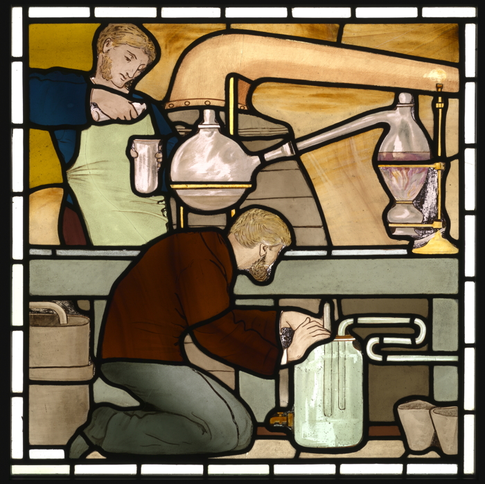
up in 1865, and still in business until 2001. One of the Maryhill stained glass windows features a pair of workers pouring molten iron into a mould – note how little in the way of protective clothing they have.
[Optional Detour: Ruchill Park &
Flagpole Viewpoint
Crossing over the canal, from here it’s a
short - but steep - walk up Firhill Street
into Ruchill Park C, where the path to
the left leads to the flagpole - one of the
highest points in Glasgow, and with an
excellent view over the whole of the city
D. To the north-east, the 165-foot high
Category A-listed water tower E is almost all that now
remains of Ruchill Infectious Diseases Hospital, dating from 1892, and designed by city architect AB MacDonald - the same person that designed Maryhill’s original Fire Station and Washhouses on Gairbraid Avenue.]
From Firhill basin, follow the towpath left where the canal passes under Firhill Road
26 Firhill Bascule Bridge
The modern bridge taking Firhill Road over the canal is a replacement for the original much smaller bascule (opening) bridge. All the bridges over the Forth & Clyde canal originally opened to allow for boats with masts - in particular fishing boats - to be able to sail through it unobstructed. This section of the canal - the Glasgow Branch - follows the curving contours of the land to maintain its level, so there are no locks needed along this portion.
Follow the canal towpath westwards as it curves around the base of Murano Street above, which was the site of a number of businesses.
27 Murano Glassworks
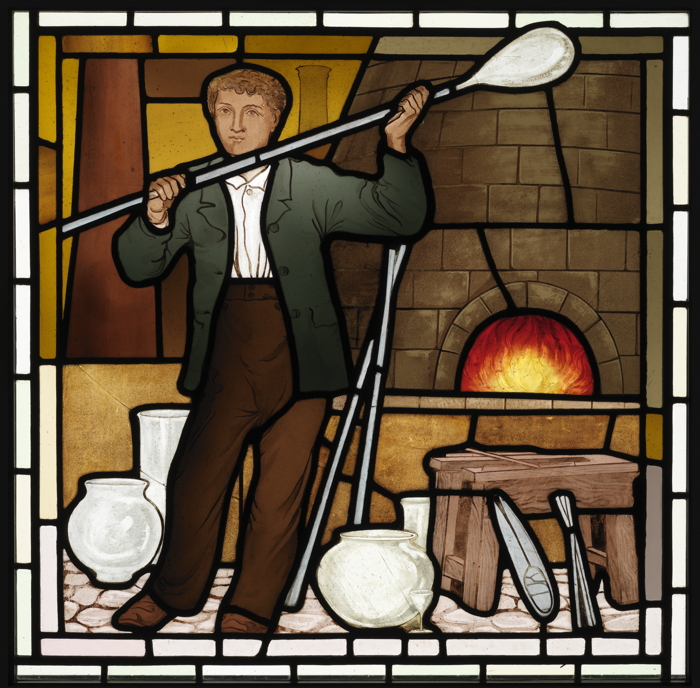 The University student village on the north bank was partly built on the site of one of the former glassworks in Maryhill
- as commemorated in the Glassblower stained glass panel. Unlike in most of the other panels, the worker shown is probably a young man, possibly an apprentice, as he doesn’t have a beard! The Caledonia Glass Bottle works,
and the Glasgow Glass
Works, which made
plate glass, had both been operating since 1874. Maryhill has been called the Venice of Scotland - on the not unreasonable grounds that there is a canal, with glassworks named after the famous Murano works in Venice!
The University student village on the north bank was partly built on the site of one of the former glassworks in Maryhill
- as commemorated in the Glassblower stained glass panel. Unlike in most of the other panels, the worker shown is probably a young man, possibly an apprentice, as he doesn’t have a beard! The Caledonia Glass Bottle works,
and the Glasgow Glass
Works, which made
plate glass, had both been operating since 1874. Maryhill has been called the Venice of Scotland - on the not unreasonable grounds that there is a canal, with glassworks named after the famous Murano works in Venice!
28 Bridge to Student Village
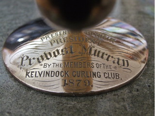 Just past the footbridge into the student village was the site of the house and business of a former Provost of Maryhill - John Murray. He owned a haulage firm, and had a well placed yard right next to the canal, where he could easily transfer goods from boats onto his carts. He
was also president of the Kelvin Dock Curling Club - which once occupied the ground now used by Maryhill FC off Lochburn Road.
Just past the footbridge into the student village was the site of the house and business of a former Provost of Maryhill - John Murray. He owned a haulage firm, and had a well placed yard right next to the canal, where he could easily transfer goods from boats onto his carts. He
was also president of the Kelvin Dock Curling Club - which once occupied the ground now used by Maryhill FC off Lochburn Road.
29 Maryhill Community Fire Station
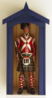 From here, across Maryhill Road can be seen the current Maryhill Community Fire Station, which opened in 1995 to replace the one in Kelbourne Street. Just to
the left of it was once a tenement
that incorporated the HLI Pub [30]
- named after the Highland Light Infantry. The pub sign, featuring
a carved wooden soldier in his
sentry box, can be seen today on display in the foyer at Maryhill
Burgh Halls. To the right and
behind is the site of North
Kelvinside School, the principal
senior educational establishment in the district for over a 100 years from 1896.
From here, across Maryhill Road can be seen the current Maryhill Community Fire Station, which opened in 1995 to replace the one in Kelbourne Street. Just to
the left of it was once a tenement
that incorporated the HLI Pub [30]
- named after the Highland Light Infantry. The pub sign, featuring
a carved wooden soldier in his
sentry box, can be seen today on display in the foyer at Maryhill
Burgh Halls. To the right and
behind is the site of North
Kelvinside School, the principal
senior educational establishment in the district for over a 100 years from 1896.
Keep following the towpath over the Bilsland Drive Aqueduct and round past...
31 Mondrian Flats - site of Maclellan Rubber
Works
The modern coloured flats on the far side of th e
canal were built on the
site of the Glasgow Rub-ber Works, run by George
MacLellan & Co. These
opened in 1871, and were
still operating up until
2003. They made all sorts of India rubber materials - from pipes to waterproof clothing, and acoustic tiles for nuclear submarines to tennis balls! The
factory was
so important to the war effort that aerial photos taken during WW2 show it was specifically targeted for bombing by the Luftwaffe. They were not successful, but the factory itself has now completely gone, although the company itself still exists, now based in England. Nearby was the intriguingly named Gold Extracting Works
[32] - this produced acid chemicals that were shipped to South Africa, but sadly not any gold itself! On the near bank was the site of the former Kelvin Chemical Works. The older brick building next to Ruchill Street was part of the offices of Alexander, Fergusson & Co’s Glasgow Lead and Colour Works [33]. Possibly it
one of these companies that was featured in the Maryhill Chemical Workers stained glass panel.
34 East Park
 To the left can be seen the modern buildings forming East Park, and beyond, the sandstone building with the spire its earliest surviving school building from around 1888. As of 1895, there were three schools in the area: Maryhill Public School, Church Street Public School, and East Park Public School. More recently, Roy Rogers & his horse Trigger visited East Park in February 1954 - a not inappropriate Hollywood connection, given that many of the later alterations to the original school building were by John Fairweather, the same architect as the famous Green’s Playhouse Cinema in Glasgow!
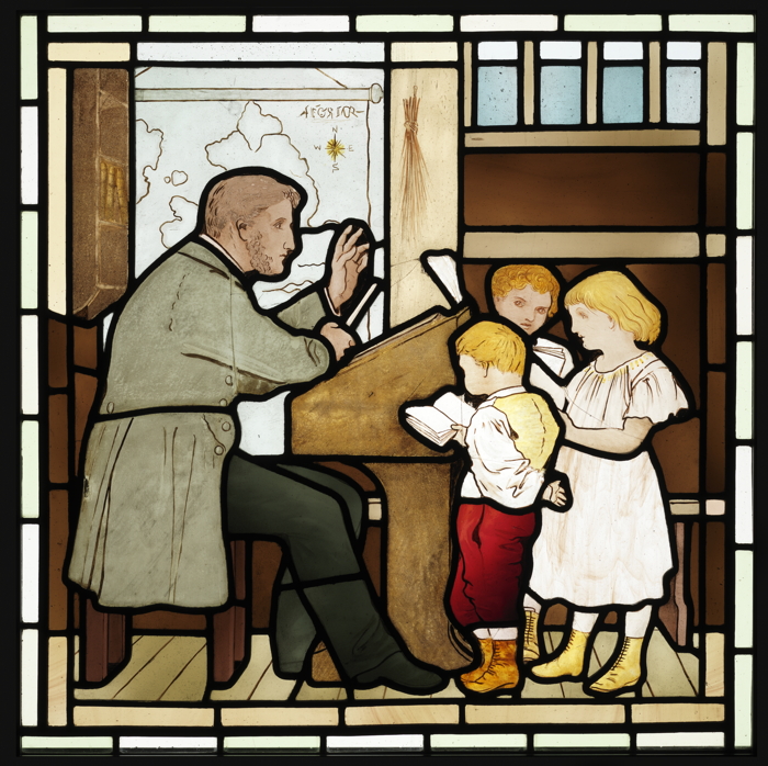 One of the Maryhill stained glass panels features a teacher and some of the children in his class - intriguingly with a map of England hanging up in the background, alongside a birch rod for punishment purposes.
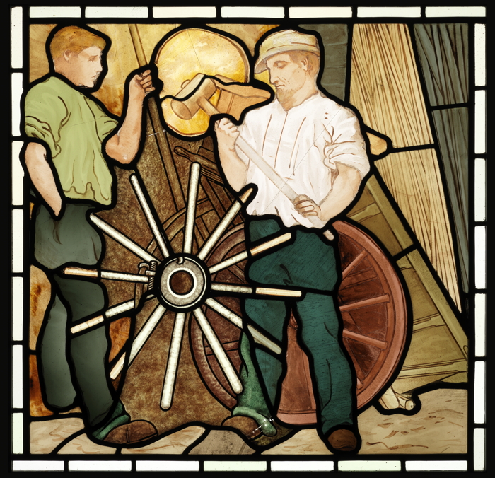
35 Site of Bascule Bridge
& Coopers Yard
The bridge that takes the road over the canal is a modern replacement for a bascule bridge built as part of the canal re-opening works. Look out for the subtle Mackintosh-inspired detailing on it, giving a hint that we’re nearly back at the Ruchill Church Hall! Nearby was a coopers yard, and also
a wheelwrights - pos
sibly the one shown
in the Wheelwrights
stained glass panel.
Just before Ruchill Street crosses the canal, leave the towpath to the left, to find yourself back at the start next to Ruchill Church Hall on Shakespeare Street.
That completes the South Maryhill Walk, and we hope you enjoyed it!